

Flooding does not really affect tourism in the Caprivi.
Yes, we do have flooding, but it mostly affects the local residents living in low-lying villages and minimally affects tourism.
Here is the different scenarios and flood history - this might give any tourist, business visitor and interested party the real vision of the watery fluctuations. Views in newspapers normally give worst, without having the true and neutral stories. In the past 2 years, river flooding has been worse, but Ovamboland has been a true flooding disaster. With the planned and coming better infrastructure, flooding in the Caprivi will pose no real threat to residents either.
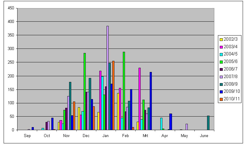
Flooding of the Zambezi River normally happens between February and April, which after the water levels slowly start to recede again. This is normally a quiet season in tourism in any case, and most lodges and campsites are built high enough on the banks of the river not to be affected. See a Graph of highest river levels in "how the Zambezi is measured.
The normal rainy season in the Caprivi is from November to March, with different regions in the Caprivi having different average annual rainfall.
2009 Zambezi Flood
Lodges, town people and local business people living in areas where the Zambezi presses up into MULAPOS (lowlying flooding marches) then travel from and to home by boat to Zambezi Lodge (town areas) or other reachable parking areas (Kalizo, Island View Lodges and Kalimbeza Fishing Camp. The 2009 floods have been the worst in 40 years, and had a more devastating effect than in 1969, when there were not nearly so many people living in the lower areas of the Caprivi. Population gain since then had been about 350 % according to reccords, and because the river had been calm the last few decades, people built their villages close to the water.
Flashfloods occur when excessive rainfall occur per day - which doesn't happen often. Because of the sandy nature of the Caprivi, these watermasses dry up quite fast. One of these flashfloods occurred in the early hours of 31 January 2009, when 105mm of rain has been recorded within 85 minutes. Houses in Katima Mulilo were flooded because there is a lack of stormwater pipes and drainage for this volumes in Katima. Some of these houses flood every year, and although the Town Council are planning the project, monies acquired was not enough.
The 2008 Kwando Flood was record breaking in all times. With the river levels reaching 4.5m (august 2008) where average is only 2.8m, the whole area around the Kwando was transformed into swampland. The Kwando reaches its peak normally in May - June, at a level of 3.2m, but in 2008 no receding of water started and the river rose and rose. Half the reason for this was excessive rains in it's catchment area in North East Angola, and half because of reeds blocking the "corner" at the Mamili National Park, where the river turns sharply to form the Linyanti River. Reed blockages normally form when the Hippos are reduced drastically and cannot keep open the channels for the water to flow through. Malyo Wilderness Camp was heavily affected, Camp Kwando slightly affected and Namushasha Lodge's Airstrip became a Mokoro (local cano) Strip.
The high levels of the river affected birds that breed in the river banks, as there were no banks in sight! Carmine Bee-eaters swirled around in treetops for weeks before starting to look for alternative breeding grounds.
Kingfishers and other bee-eaters as well as Jacana and Purple Galinule didn't reach full breeding potential due to the swamped banks and faster flowing water.
By Niqui Bosch
Yes, we do have flooding, but it mostly affects the local residents living in low-lying villages and minimally affects tourism.
Here is the different scenarios and flood history - this might give any tourist, business visitor and interested party the real vision of the watery fluctuations. Views in newspapers normally give worst, without having the true and neutral stories. In the past 2 years, river flooding has been worse, but Ovamboland has been a true flooding disaster. With the planned and coming better infrastructure, flooding in the Caprivi will pose no real threat to residents either.
Flooding of the Zambezi River normally happens between February and April, which after the water levels slowly start to recede again. This is normally a quiet season in tourism in any case, and most lodges and campsites are built high enough on the banks of the river not to be affected. See a Graph of highest river levels in "how the Zambezi is measured.
The normal rainy season in the Caprivi is from November to March, with different regions in the Caprivi having different average annual rainfall.
2009 Zambezi Flood
Lodges, town people and local business people living in areas where the Zambezi presses up into MULAPOS (lowlying flooding marches) then travel from and to home by boat to Zambezi Lodge (town areas) or other reachable parking areas (Kalizo, Island View Lodges and Kalimbeza Fishing Camp. The 2009 floods have been the worst in 40 years, and had a more devastating effect than in 1969, when there were not nearly so many people living in the lower areas of the Caprivi. Population gain since then had been about 350 % according to reccords, and because the river had been calm the last few decades, people built their villages close to the water.
Flashfloods occur when excessive rainfall occur per day - which doesn't happen often. Because of the sandy nature of the Caprivi, these watermasses dry up quite fast. One of these flashfloods occurred in the early hours of 31 January 2009, when 105mm of rain has been recorded within 85 minutes. Houses in Katima Mulilo were flooded because there is a lack of stormwater pipes and drainage for this volumes in Katima. Some of these houses flood every year, and although the Town Council are planning the project, monies acquired was not enough.
The 2008 Kwando Flood was record breaking in all times. With the river levels reaching 4.5m (august 2008) where average is only 2.8m, the whole area around the Kwando was transformed into swampland. The Kwando reaches its peak normally in May - June, at a level of 3.2m, but in 2008 no receding of water started and the river rose and rose. Half the reason for this was excessive rains in it's catchment area in North East Angola, and half because of reeds blocking the "corner" at the Mamili National Park, where the river turns sharply to form the Linyanti River. Reed blockages normally form when the Hippos are reduced drastically and cannot keep open the channels for the water to flow through. Malyo Wilderness Camp was heavily affected, Camp Kwando slightly affected and Namushasha Lodge's Airstrip became a Mokoro (local cano) Strip.
The high levels of the river affected birds that breed in the river banks, as there were no banks in sight! Carmine Bee-eaters swirled around in treetops for weeks before starting to look for alternative breeding grounds.
Kingfishers and other bee-eaters as well as Jacana and Purple Galinule didn't reach full breeding potential due to the swamped banks and faster flowing water.
By Niqui Bosch


15 February 2007
taken by Frik Strauss
taken by Frik Strauss
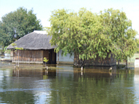
Flood 2007: Kalimbeza Fishing Camp
23 March 2007
23 March 2007
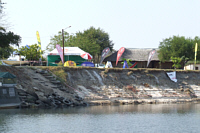
9 June 2007
25 August 2007

The 2007 Zambezi Flood has been the worst since 1979. Some of the Lodges and residential houses along the Zambezi were quite badly affected, some warding off the water with sandbags, some built walls to keep the water out temporarily. Mukusi River Lodge was closed as water was about half a meter deep in the bar and conference rooms.
This flooding was due to excessive rainfall in the Zambezi's catchment area, in northwest Zambia. Where the average measurement in the river peak is about 6.5 m (see the link on "how the Zambezi is measured") the water went up to 7.38m, spilling over the highest of the river banks. Whole islands were swallowed and all of the local fishermen's camps have been destroyed. Schools and villages lying very low has been flooded and after the 2008 level, which was not as high on 6.85, whole villages were told by the local authorities so plan on moving to higher ground. For 5 years before these floods, the Caprivi had drought.
This flooding was due to excessive rainfall in the Zambezi's catchment area, in northwest Zambia. Where the average measurement in the river peak is about 6.5 m (see the link on "how the Zambezi is measured") the water went up to 7.38m, spilling over the highest of the river banks. Whole islands were swallowed and all of the local fishermen's camps have been destroyed. Schools and villages lying very low has been flooded and after the 2008 level, which was not as high on 6.85, whole villages were told by the local authorities so plan on moving to higher ground. For 5 years before these floods, the Caprivi had drought.
THE LEVEL OF THE ZAMBEZI AT KATIMA MULILO IS
6.55m (Stable,4 April 2011)
BUDGET CAR HIRE SPECIAL!!!
NOW's the time to plan your special trip!!
RENT A 4X4 Double Cab From: 28 JAN to 30 APRIL 2011
Rate : R/N$410 per day, 200km included per day; R/N$5.17 per additional km.
STANDARD WAIVERS INCLUDED (Standard Insurance - theft or accident)
CARS AVAILABLE IN RSA FREE STATE AND NAMIBIA ONLY
Click here / logo button to place your enquiry/ booking
or PHONE YOUR NEAREST AGENT ASAP - Limited Cars!

Visit NAMIBIA NOW: the Caprivi Wetlands in action,
a blooming desert, ; Etosha's Pans Filled!
a blooming desert, ; Etosha's Pans Filled!

Zambezi River Levels: Year and highest level reached.
As at 23 February 2011

Total rainfall per season
2011 - as at 23 February 2011
2011 - as at 23 February 2011
2011 - as at 23 February 2011