Drops / Light Rain Rain
Light Rain Moderate Rain

2010 Flooding Season
After a rapid rise in the Zambezi river due to heavy rains in the catchment area, the flooding started again...
François and I have been monitoring the steady rise of the river so that you can also see what we did - you will find photos taken at the same place in a ten day period, so you can compare for yourself...
The Road to Namwi Island is Flooded, The Road to Caprivi River Lodge is also flooded, but safe parking is available while you will receive a free Mokoro Trip (local boat) to escort you and your luggage over the Mulapo (A water filled lowland, flooded by the river when rising. The road to Kalizo is also flooded, they will also fetch you by boat, and the Road to Island View is expected to be under water shortly.
Please note the lodges are NOT closed, at this stage, but you will have to organize with them for transport by boat - getting you closer to Africa, what an Experience!!
These satellite images, taken by Namibia Weather (click to enter) which is a most acurate site. The map (in the Namibia Weather site) is movable (just click, hold and drag). Acknowledgement and Thanks to Namibia Weather.
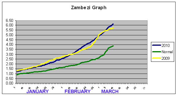
THE PEAK LEVEL OF THE ZAMBEZI AT KATIMA MULILO WAS
7.37m (21 March 2010)
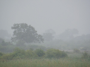
Heavy rain in the Catchment Area: 4 March 2010
By Niqui Bosch

The graph shows the normal level of the river, last years level (resulted in bad flooding 2009) and the level for this year. The data has been given by Namibia Hydrology - A special thanks to Guido van Langenhove, all the readers (they also do Kwando, Kavango, Kunene, Orange Rivers etc) and all the other people that makes it possible for us to know all the readings, history etc. Greatly appreciated!


4 March 2010 8 march 2010 12 March 2010
Taken at a road goint to the river, at the Western side of the Zambezi Waterfront:


4 March 2010 8 march 2010 12 March 2010
Taken at the Slipway (boatlaunch) at Civvy Club, between Waterfront and Protea Hotel

Heavy rain in the Catchment Area: 11 March 2010


2 March 2010 6 March 2010 9 March 2010 12 March 2010
Taken at the Katima Water Tower, Official level reading site of the Zambezi at Katima


See the reeds & grass in front disappear, as well as the trees to the right of the tower (on an Island) The last photo was taken from further back, as the path we normally use was under water and a new standing point had to be taken.
5.16 m 5.81m 6.15 m (07h00, this at 6.19 11h00) 6.70m (07h00, this at 6.75, 11h00)
Taken at the New Demolished Mukusi River Bar (due to last years floods) at the Eastern side of the Zambezi Waterfront:

2 March 2010 6 March 2010 9 March 2010 12 March 2010


7.32m (27 March 2010)