

15 February 2007
taken by Frik Strauss
taken by Frik Strauss
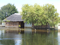
Flood 2007: Kalimbeza Fishing Camp
23 March 2007
23 March 2007
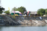
9 June 2007
25 August 2007

·History of the Region:
The Caprivi Region has a unique history. Unlike other regions in Namibia, the Caprivi is something different. Until the end of the 19th century it was known as Intenga and under rule of the Lozi kings, but later forming part of the British Bechuanaland Protectorate (known as Botswana today). In 1890 Germany laid claim to the British administered Island of Zanzibar, but the British objected. This was then settled at the Berlin Conference in 1890 when Queen Victoria acquired Zanzibar and Germany acquired the territory which is now known as the Caprivi strip. The Caprivi strip was named after the German Chancellor General Count George Leo von Caprivi di Caprara di Montecuccoli.
The Swap of Land between Germany and England:
The reason behind the swap was to acquire a strip of land that would be added to German South West Africa, linking the Zambezi River, Lake Tanganyika and the Indian Ocean via another German colony Tanzania (German East Africa). It seems that the Germans were oblivious to the fact that the Victoria Falls was downstream and their plans to use the mighty Zambezi to access the Indian Ocean was naturally out of the question. The capital of the Caprivi was at Schuckmansburg until around 1933, when it was moved to Katima Mulilo. It was then administered by South Africa from Pretoria and from 1981 to 1990 ruled by the Administration for the Caprivians as part of South West Africa. The transitional period from 1990 to 1992 was followed by Namibian Independence on 21 March 1990. In 1992 the Caprivi became one of the 13 political regions in Namibia with its own Regional Governor and six councilors. Today still the Caprivi has a Governor who governs the region with six constituencies headed by councilors. There are also Traditional Leaders who govern in the old traditional method with a chief and all his tribal leaders. Each area is under control of an Induna (Chief) and the Indunas form the governing Traditional Council.
Lake Liambezi also has a strange history. Less than 50 years ago there was no lake. In 1958 the Zambezi rose to the highest levels ever recorded. It flooded the entire eastern portion of the Caprivi pouring into a broad depression located south of Katima Mulilo and thereby creating a lake now known as Lake Liambezi. Most of the time this lake is dry. Lake Liambezi also receives water from the Kwando- turn Linyanti River, but received very little water from here as well.An interesting (and possibly true) theory as to why Lake Liambezi dried up after the floods of 1958, is the poaching of abundance of hippo. This apparently caused the channels (which were always kept open by the hippo) to close-up thus preventing water from flowing into the lake and so, ironically, deprived the local population of a plentiful supply of fish. Even with the high Zambezi floods in 2007 and the 2008 Kwando Flood the lake received very little water at all - giving more proof of the hippo-theory.
Rerouted to Independent websites. Views expressed are not all caprivi.biz views.
Articles about the last 10 years.....