How the Zambezi integrates with the Chobe and Linyanti Rivers
The Caprivi is mostly surrounded by rivers. To understand how these rivers integrate, we firstly need to see where they are lying.
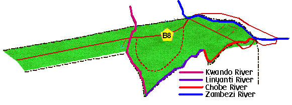
The Kwando river, coming from Angola and forming a the southernmost part of the border between Zambia and Angola, flows down over the Caprivi strip, to start forming the border between Namibia and Botswana. At the Sourthern tip of Namibia, the river makes a sharp turn, however and starts flowing northward again. From this turn, the river is known as the Linyanti. The river turns again, and is then called the Chobe. This river(s) is a constant flowing river, although sometimes it's only seen as a thin "tricle". When the Kwando comes to flood, water pushes up with the Linyanti river, and into the Chobe, which pushes up to join up with the Zambezi river at Impalila Island, where four countries meet. (Namibia, Botswana, Zambia and Zimbabwe)
If the Zambezi is flooding though, it pushes down into the Chobe river, turning around the flow of the Chobe. In a flood as bad as this year's one, it pushes down with high speed. Because of the high level of the Kwando river and into the Linyanti, the water then collides where the Linyanti meets the Chobe, and spills north into Lake Liambezi in the Caprivi, and south into the floodplains of Botswana.
If the Zambezi is flooding though, it pushes down into the Chobe river, turning around the flow of the Chobe. In a flood as bad as this year's one, it pushes down with high speed. Because of the high level of the Kwando river and into the Linyanti, the water then collides where the Linyanti meets the Chobe, and spills north into Lake Liambezi in the Caprivi, and south into the floodplains of Botswana.